

Tsum Valley Trek (10-11 Days) 11 Days Guide
Trail notes for Tsum Valley Trek (10-11 Days). Daily walking hours, pass elevations, teahouse stops, and permit logistics.
Tsum Valley Trek
11-day route along Tsum Valley Trek. Daily climbs range from 400m to 900m on rock and stone stairs. Cold nights above 3,500m.
Key Trail Realities
What to expect along the route
Restricted Border Valley Access
Enter the culturally Tibetan Tsum Valley through strict checkpoints requiring specialized permits and licensed guide accompaniment.
Ancient Buddhist Monasteries
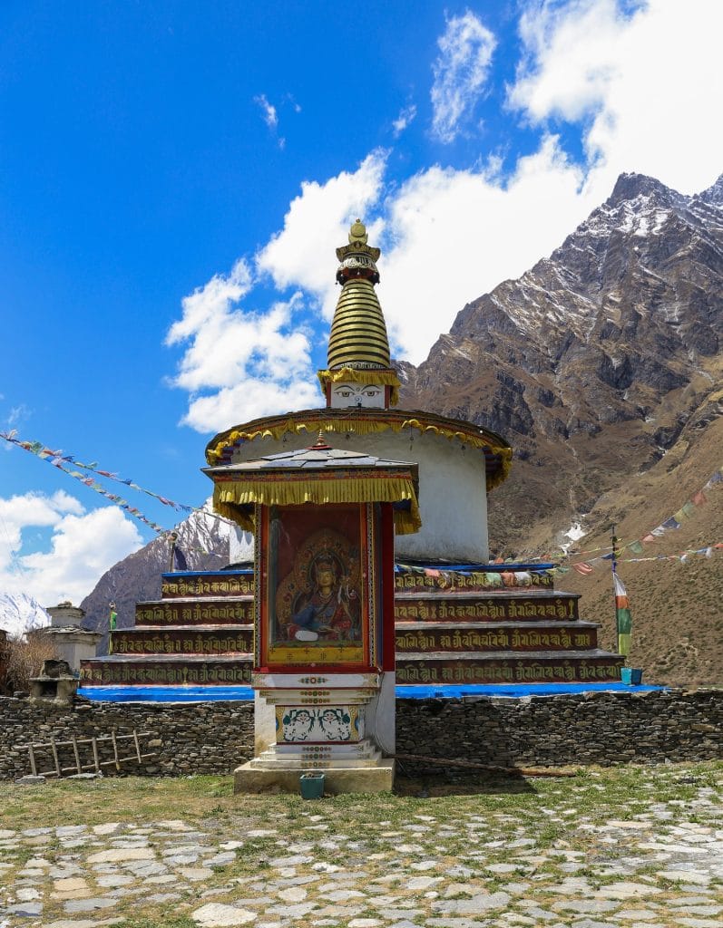
Visit historic gompas such as Rachen and Mu Gompa nestled against high mountain walls near the Tibetan frontier.
Steep Gorge and Suspension Bridge Crossings
Traverse narrow suspension bridges spanning the raging Buri Gandaki river gorge along steep stone staircases.
Traditional Stone Villages
Pass through tightly clustered Tibetan-style stone houses featuring flat roofs stacked with firewood and drying crops.
High Altitude Valley Floor
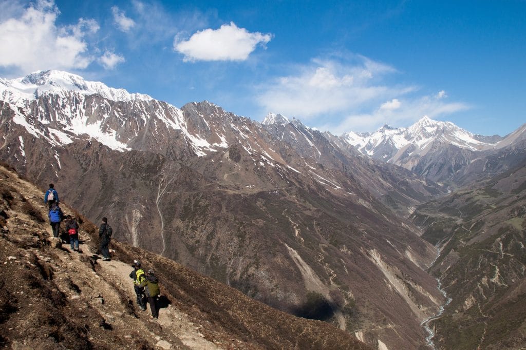
Ascend gradually into wide, windswept glacial valleys framed by the Ganesh Himal and Sringi Himal ranges.
Rugged Road and Trail Connections
Begin the journey via a rough overland jeep drive from Kathmandu connecting to the restricted area trailhead at Soti Khola or Machha Khola.
Basic Teahouse Infrastructure
Stay in family-run lodges offering simple rooms, wood-stoved dining halls, and limited electrical charging facilities.
High Mountain Pass Views
Witness sweeping vistas of snow-capped border peaks from high vantage points above 3,500 meters.
Trail Photos & Videos
High-definition captures and video clips from Himalayan passes, glacial lakes, Sherpa villages, and mountain summits.



Tsum Valley Trek (10-11 Days) Trail Map
Interactive OpenStreetMap topographic trail map tracing the route.
Key High-Altitude Stops
Compatible with Garmin, Apple Watch, Strava & Gaia GPS
Tsum Valley Trek (10-11 Days) Weather Center
Real-time mountain weather and 5-day altitude forecasts across key Tsum Valley Trek (10-11 Days) waypoints.
Loading weather for ...
Choose waypoint
Altitude Chart & Acclimatization Nodes
Strict adherence to "Hike High, Sleep Low" ensures safe high-altitude adaptation.
Complete Itinerary Route
Explore the detailed day-by-day routing, acclimatization schedule, and trek milestones.
Arrival in Kathmandu (1,350m)
HighlightLand at Tribhuvan International Airport and transfer to Thamel. Afternoon gear check — verify restricted-area permits, trekking poles, and warm layers for 3,700m nights. Evening briefing covers Tsum Valley's cultural protocols, monastery etiquette, and the non-negotiable descent rule if altitude symptoms appear.
Kathmandu to Soti Khola (700m)
06:00 AM departure via Prithvi Highway to Arughat, then rough dirt track along Budhi Gandaki. Landslide delays common after monsoon — pack snacks and water. Arrive mid-afternoon at riverside settlement; hot shower available for NPR 300. Early night — tomorrow the walking starts.
Soti Khola to Machha Khola (900m)
HighlightTrail clings to rocky bluffs above the Budhi Gandaki — nine suspension bridges today, each swaying under loaded mules. Pass Gurung villages with maize drying on stone walls. Steep final climb to Machha Khola; lodges cluster near the river. Cold beer sometimes available if porters carried it up.
Machha Khola to Jagat (1,340m)
Cross to true left bank at Khorlabesi, then ascend through subtropical forest to Tatopani's natural hot springs — worth a 20-minute soak if time allows. Stone stairs steepen past Dovan; landslide zone requires careful footing. Jagat sits on a terrace with ACAP checkpost; permits verified here before entering Tsum Valley tomorrow.
Jagat to Lokpa (2,240m)
HighlightSharp turn north at Philim — leave Manaslu Circuit trail for Tsum Valley restricted area. Steep climb through pine and rhododendron to Ekle Bhatti, then descend to Siyar Khola bridge. Final grind up exposed switchbacks to Lokpa, the valley's gateway. Only three lodges; book beds on arrival. Temperature drops noticeably after sunset.
Lokpa to Chumling (2,386m)
HighlightGentle day by Himalayan standards — traverse forested ridge with first views of Ganesh Himal's north face. Pass mani walls and chortens marking Tibetan Buddhist influence. Chumling's gompa sits above the village; monks welcome visitors for butter-lamp offerings. Lodges basic but warm; solar showers work on sunny afternoons.
Chumling to Chhokangparo (3,010m)
HighlightCross Siyar Khola on a cantilever bridge, then climb stone steps through barley fields to Rainjham. Trail steepens past Gho — watch for blue sheep on cliffs above. Chhokangparo (two merged villages: Chhekampar and Chhokang) unfolds on a glacial terrace. Solar panels charge devices for NPR 100/hour; buy boiled water instead of plastic bottles.
Chhokangparo to Nile (3,361m) via Mu Gompa (3,700m)
HighlightMorning climb to Mu Gompa — Tsum's largest monastery, founded 1895. Hundreds of prayer flags frame views of Tibetan border peaks. Continue 40 minutes across wind-scoured plateau to Nile, the valley's highest settlement. Only two lodges; rooms unheated. Sleep with hot water bottle; night temps hit -10°C in October.
Acclimatization day at Nile — Mu Gompa & Dhephyudonma Gompa
AcclimatizationHike 400m up to Dhephyudonma Gompa (4,000m) for panoramic views into Tibet — no permit needed for this side trip. Return via Mu Gompa's ancient scriptures and 108-bead prayer wheel. Rest afternoon; monitor for headache, appetite loss, or stumbling gait. Extra garlic soup and black tea count toward hydration. Descend immediately if symptoms worsen.
Nile to Jagat (1,340m)
HighlightLong descent — retrace plateau to Chhokangparo, then drop 1,670m via Lokpa and Philim to Jagat. Knees take a pounding on endless stone stairs; trekking poles essential. Pass through restricted-area checkpoint at Philim; permits stamped for exit. Jagat feels luxurious after Nile — hot showers, wifi, and a bakery selling apple pie.
Jagat to Soti Khola, drive to Kathmandu
Final trek leg: downriver through Tatopani to Machha Khola, then Soti Khola by early afternoon. Jeep waits for bone-rattling return drive — landslides can add hours. Arrive Kathmandu late evening; book post-trek massage in Thamel. Permit copies and TIMS card returned to agency; keep photos for insurance claims.
What's Covered & What's Not
A clear breakdown so you know exactly what to budget for and what's already taken care of.
Required Trail Permits
- Manaslu Conservation Area Permit (MCAP), Tsum Valley Restricted Area Permit, and Annapurna Conservation Area Permit (ACAP) connection fee.
Local Transport
- Shared four-wheel-drive jeep transport from Kathmandu up to Soti Khola or Machha Khola trailhead.
Teahouse Accommodation
- Basic twin-share lodge room throughout the Tsum Valley settlements.
Mandatory Licensed Guide
- Government-registered local guide required for restricted area entry.
International Flights
- Airfare from your home country into Tribhuvan International Airport.
Nepal Tourist Visa
- On-arrival tourist visa fee ($30 USD for 15 days, $50 USD for 30 days).
Helicopter Evacuation Insurance
- Mandatory travel policy covering emergency helicopter airlift up to 4,000m.
Trail Incidentals
- Hot showers, battery charging fees, and personal snack purchases at teahouses.
Trail Meals & Hydration Rules
What to eat for stamina and altitude safety
Dhal Bhat Power
Rice, lentil soup, spiced potato, and seasonal greens. Always comes with free refills to refuel after long trail hours in the Tsum Valley.
Garlic Soup
Thin clear garlic broth served hot in teahouses. Consumed by trekkers to help with throat comfort and circulation in dry mountain air.
Boiled & Fried Potatoes
Dense carbohydrate source produced locally in the upper valley settlements and served with local salt or chili paste.
Tibetan Bread & Honey
Deep-fried flatbread available in valley lodges, providing high calories before an early morning push.
Noodle Soup
Hot broth with noodles and mixed vegetables, common for lunch stops at roadside tea shops.
Boiled Eggs
Reliable morning protein source ordered directly from lodge kitchens before departure.
Boiled Water Refills
Fill bottles with boiled water at teahouses each evening and keep the container inside your sleeping bag to prevent freezing.
Ginger Lemon Honey Tea
Hot herbal drink that provides warmth and soothing relief against the dry valley air.
Electrolyte Mixes
Add electrolyte powders to your water bottle to maintain salt balance during sustained climbs.
Purification Tablets
Use chlorine dioxide or iodine tablets for tap water sources, allowing adequate contact time before drinking.
Vegetarian Focus
Plant-based meals are the most reliable option across remote valley lodges where refrigeration does not exist.
Rice and Potato Staples
Naturally grain-based dishes dominate lodge menus, making carbohydrate intake straightforward.
Black Tea Preference
Order black tea or black coffee if you prefer to avoid powdered milk used in standard milk tea.
Kitchen Coordination
Place dinner orders early in the afternoon so lodge operators have adequate time to prepare food.
Meat in Upper Villages
Avoid meat dishes in remote upper settlements where porter-carried supplies lack refrigeration.
Alcohol at Altitude
Refrain from drinking alcohol during the ascent, as it accelerates dehydration and complicates altitude adjustment.
Untreated Tap Water
Never drink unboiled stream or tap water directly without prior filtration or chemical treatment.
Uncooked Vegetables
Skip raw green salads and unpeeled fresh fruits to prevent gastrointestinal illness on the trail.
Trip Preparation & Rules
Paperwork, restricted area permits, and cash guidelines
Passport & Tourist Visa
Passport valid for at least 6 months. Secure a 30-day tourist visa on arrival at Kathmandu airport using cash USD.
Emergency Evacuation Insurance
Insurance policy must explicitly cover emergency helicopter rescue and medical evacuation above 4,000 meters.
Passport-Sized Photographs
Keep at least 4 printed passport photos ready for restricted area permit applications and trekking registrations.
Manaslu & Tsum Valley Restricted Area Permits
Requires a registered guide and a minimum of two trekkers. Permits are managed through an authorized trekking agency.
MCAP Entry Permit
Manaslu Conservation Area Project permit is mandatory and verified at various checkpoint stations along the trail.
TIMS Card Alternative
Standard TIMS card is replaced by the restricted area permits and MCAP when entering this protected northern corridor.
Shorter Overland Drive
Access begins with a road journey from Kathmandu to Machha Khola via Arughat or Soti Khola, avoiding domestic mountain flights.
Road Conditions Check
Monsoon rains and winter landslides frequently impact dirt mountain roads; confirm jeep availability with transport operators before departing.
Vehicle Baggage Management
Pack gear in durable, water-resistant duffels suitable for roof rack transport on local shared or private four-wheel-drive jeeps.
Cash in Nepalese Rupees
Bring sufficient physical cash from Kathmandu. No functional ATMs exist past Arughat or Soti Khola.
Small Denominations
Carry smaller rupee notes (Rs 100, 500) for tea houses, local shops, and monastery donation boxes.
Digital Payment Limitations
Credit cards and mobile banking are completely unusable throughout the upper valley due to lack of reliable connectivity.
Trail Customs & Rules
Practical rules for passing animals, stupas, and village paths
Pass Stupas Clockwise
- •Always keep Mani stones and chortens on your right side.
- •Spin prayer wheels clockwise.
- •Never sit on inscribed prayer stones.
Pack Animal Right-of-Way
- •Stand on the mountain wall side when yaks or mules pass.
- •Never stand near the cliff edge.
- •Give the caravan space and wait for dust to settle.
Photo Etiquette
- •Ask before taking photos of local villagers or monks.
- •Do not use flash inside monastery prayer rooms.
- •Drop Rs 100–200 in the donation box if visiting monasteries.
Trash & Water Ethics
- •Pack all plastic snack wrappers back to Kathmandu.
- •Never throw batteries or wet wipes in pit toilets.
- •Use purification tablets instead of buying single-use plastic bottles.
Sacred Valley Respect
- •Tsum Valley is a beyul (sacred hidden land) with strict Tibetan Buddhist traditions.
- •Avoid hunting, trapping, or killing any wildlife.
- •Observe local requests regarding restricted zones around ancient gompas.
Teahouse and Homestay Etiquette
- •Remove boots before entering carpeted dining areas or sleeping rooms.
- •Order breakfast the night before to help kitchen staff prepare early.
- •Keep common areas quiet after 9:00 PM as local families sleep nearby.
Permits & Emergency Directory
Current permit fee structures and official emergency contacts for the Tsum Valley route
Required Permits & Mandatory Fees
-
📜Manaslu Conservation Area Permit (MCAP) NPR 3,000
Mandatory entry permit for the Manaslu Conservation Area, required for all trekkers entering the Tsum Valley region.
-
📜Tsum Valley Restricted Area Permit $40 USD per week
Special restricted area permit required for the Tsum Valley section, with seasonal fee variations; must be processed through a registered local agency.
-
📜Annapurna Conservation Area Permit (ACAP) NPR 3,000
Required if extending the route across the Manaslu-Annapurna border or descending via standard Annapurna connecting trails.
Nepal Tourism Directory
Official contact channels for permits, park regulations, and emergency rescue assistance.
Power, Connectivity & Showers
Realistic day-to-day guide for charging, phones, and hygiene
Device Charging
Charging fees in lower Tsum Valley lodges range from NPR 200 to 400 per device, rising further at higher elevations. Carry a 20,000mAh power bank to minimize reliance on lodge outlets.
Mobile SIM & Data
Nepal Telecom (NTC) provides sporadic signal up to Lokpa and Chumling, while Ncell coverage drops out earlier. Expect limited data connectivity beyond upper valley settlements.
Hot Showers
Basic bucket or gas-heated showers are available in lower villages for NPR 300 to 500. Above 3,500 meters, freezing temperatures make hot water scarce; rely on wet wipes.
Electricity & Lighting
Most teahouses operate on small local micro-hydro or solar setups. Bring a reliable headlamp with spare batteries for unlit hallways and early morning departures.
Altitude Safety & Health
How to handle altitude symptoms and emergency protocols
Daily Symptom Monitoring
Watch closely for early AMS signs: persistent headache, loss of appetite, nausea, dizziness, and insomnia.
Helicopter Evacuation
In case of severe HAPE or HACE, guides dispatch emergency rescue helicopters to Kathmandu hospitals.
Satellite SOS Communication
Carry a Garmin inReach or ensure your guide carries satellite SOS for dead-zone sections.
Hydration and Electrolytes
Count hot lemon, black tea, and garlic soup toward daily hydration goals to maintain fluid balance above 3,000 meters.
The Golden Altitude Rule
If you have a headache, nausea, or dizziness, do NOT ascend. If symptoms worsen after resting, descend 300 to 500 meters immediately. Descent is the only guaranteed cure.
Tsum Valley Heritage & network
Indigenous Tibetan-influenced communities and wildlife along the Tsum Valley route
Tsumba Culture & Language
The indigenous Tsumba people preserve a distinct Tibetan dialect, unique architectural styles, and ancient Buddhist traditions.
Traditional Stone Villages
Clusters of multi-storied stone houses in settlements like Chhokangparo and Ngakyu Leru, featuring flat timber roofs and stacked firewood.
Traditional Wool Weaving
Local artisans spin sheep and yak wool into durable winter garments, blankets, and traditional aprons worn across the valley.
Rachen Gompa & Mu Gompa
Historic monastic centers housing sacred Buddhist texts, large prayer wheels, and murals reflecting centuries of religious practice.
Nye Enclosures & Mani Walls
Extensive stone mani walls and sacred valley boundaries where hunting is traditionally restricted as part of local spiritual laws.
Sringi Himal Guardianship
Mount Sringi, rising above the valley, is revered as a sacred protector deity by the local Tsumba communities.
Blue Sheep & Himalayan Wildlife
Steep slopes and rocky outcrops support populations of bharal (blue sheep) and occasional sightings of elusive snow leopards.
Pine and Rhododendron Forests
Lower gorge sections transition from dense blue pine and oak forests into vibrant sub-alpine rhododendron groves.
High-Altitude Raptors
Lammergeiers, golden eagles, and Himalayan griffons frequently ride thermal updrafts above the Shiar Khola river basin.
Essential Packing Checklist
Prepare 1 duffel bag (handled by porter team) and 1 daypack for personal warm layers & water.
Frequently Asked Questions
Practical details for planning your journey into the Tsum Valley